Archive

Monthly Archives: December 2011

Walking Routes and Wales Walks

North Wales

North Wales is a favourite among walkers, and it’s easy to see why with such beautiful Wales walks.

This part of Wales is home to Snowdonia National Park which boasts almost 840 square miles of mountains, lakes and beautifully diverse walking terrain. There’s also Anglesey, Wales’ largest island featuring an area of Outstanding Natural Beauty, and let’s not forget about some of the best coastal walking in the country along the North Wales Coast walking routes.

There’s also an abundance of gentle strolls and more challenging, steeper climbs to be found in the North Wales borderlands.

Snowdonia Mountains and Coast

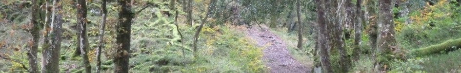
The Snowdonia National Park contains some of the most dazzling mountain scenery in the uk. With their reputation for rough rocky outcrops, vertiginously sheer cliffs and scooped glacial cwms, the mountains have shaped the livelihood of the people who’ve lived here.

When walking in this area we advise that you take a compass and be prepared for sudden changes in weather. And remember there will be limited mobile phone coverage!

Only a short distance away from this spectacular land of mountains you can discover breathtaking coastline. The Llyn Coastal Footpath provides you golden opportunity to experience the coastal landscape by following this winding route. There are small coves and wide expanses of sand, rugged cliffs and small harbours waiting to be discovered.

Wales Walks - Walking Routes - Snowdon Walks

Wales Walks - Walking Routes - Snowdon Walks

Llyn Peninsula

Morning on the Llyn Peninsula is spectacular. Almost anywhere you stay, the sea is there when you open the curtains.

The pointy mountains are an extinct range of volcanoes and you’re never far from them. Families with children come here because you can pretty much count on being able to go walking from your front door. You don’t have to travel far, and if you did want to travel, to Portmeirion, say, or to Caernarfon for the shops and castle, Llyn’s a small place and the journeys are short. You can feel cut off without actually being cut off.

Llyn’s popular beaches offer some of the best surfing in the whole of Wales. And there are also big, quiet stretches of sand like Porth Oer, known as Whistling Sands because the dry sand squeaks as you walk on it.
Mid Wales

Mid Wales is reserved especially for you. No crowds, no hassle, no pressure.

You have the choice between a scenic coastline with award winning beaches or entering the gentle heartland where the scenery is spectacular. Wherever you decide, the roads will be quiet and the vibrant towns will welcome you with open arms.
South Wales

Go West or Go East?

South West Wales is made up of the beautiful moors, rolling hills, beaches and cliff tops of Swansea Bay, Carmarthenshire and Pembrokeshire – home to the UK’s only coastal national park and Wales’ longest national trail.

Travelling East across South Wales you will find trails through deep valleys, Welsh waterfalls and hilltops, along canals and rivers and the first coastline in Wales to be awarded Heritage Coast protection.

UK Walking Towards South Wales

Typically the Brecon Beacons in UK walking towards the south Wales offers walks not to mention walking routes as varied whenever you could imagine. An portion of true outstanding natural loveliness its landscape is intertwined with the help of exploitation, conservation, preservation not to mention recreation of Wales walks.

The Brecon Beacons, defined by your Brecon Beacons National Meadow, has embraced the have got to protect this beautiful section with investment and eco consciousness. The area has the tallest, roughest, toughest peaks in South Wales engulfed in your boundless terrain, swooping escarpments, vast vistas, impressive tarns (waters formed by glacial formations) and then the barren moorlands.

The sudden transition out of your tranquillity and the breathtaking scenery of this Brecon Beacons to typically the coal bearing valleys legacy of this industrial revolution is essentially instant.

Merthyr Tydfil were once the largest town in Wales accompanied by a legend dating back towards 480 when Saint Tydfil was basically slain by pagans. In her honour the city was renamed Merthyr Tydfil, with Merthyr posting modern Welsh translation from Martyr. With the growth of this iron industry, several wars and then the rapid expansion of railways meant the city grew until its height in 1861. By the 1930’s soon after World War I the place and industry was through decline. All that remained of this Dowlais ironworks finally enclosed in 1987 marking the bottom of 228 years from continuous production from can a big, many sites.

Close from is Port Talbot, the domestic in 1952 of undoubtedly one of Europe’s biggest steelworks and then the then largest employer through Wales. A chemical plant through 1960 and deep-water harbour renovation in 1970 meant the place was good for town but a ruin with the landscape.

Herein lays the value of maintaining rural South Wales aided by the Brecon Beacons being typically the saviour of tourism and then the Gower Peninsula by Swansea selling wonderful holiday spots for ones beach lovers and coastal walkers.

The Brecon Beacons National Park is made with a consistent character of wave upon wave of open hillside and obvious mountain air. The terrain dips, rolls and rises fluidly for a giant green sea. Walking routes in your Brecon Beacons are uncomplicated with wide open spaces and vast air above, easy to fully grasp but ruthlessly draining with the help of slow steady climbs who seem endless.

The Black Mountains will be first of the 3 main mountain ranges in your Brecon Beacons, a lofty array of hills along the Welsh/English boundary. The Brecon Beacons might possibly be the heart of the Brecon Beacons National Park and then the west are typically the moors and plateaux from Fforest Fawr. The loneliest of mountain ranges is at the far west of this Brecon Beacons, Black Mountain peak; a daunting wilderness for ones very brave explorer.

As compared to its northern counterpart, typically the Snowdonia National Park, the Brecon Beacons is more reliable in comparison to the lucky-dip landscape of boulder strewn slopes, jagged pinnacles, boggy moors not to mention woodland valleys.

Whilst Mount Snowdon and then the Snowdonia National Park may could be seen as the preferred choice for ones more adventurous the Brecon Beacons beholds rarer from treasures; the Welsh waterfalls. The Welsh waterfalls are actually almost as endless being the mountain ranges and are in the ancient woodlands and forest pathways close to the Brecon Beacons.

The feeling of walking into, near, up and below, inside and in the vicinity of a Welsh waterfall can be described as definite rival to the multitude of peaks and cwms from Mount Snowdon.

Free UK Walking Routes – Epping Forest

Epping Woodland was originally reserved like a royal hunting ground. That’s the hunting ground for royalty to hunt, not to really hunt the royals!

If you don’t zig zag around the actual forest, it is quite a stretch to obtain more than a 2 hour walk from the forest unless you adhere to the The Epping Forest Method which starts in Loughton as well as heads straight upwards in order to Hatfield, covering a great 25 miles.

Free UK Walking Routes

Free UK Walking Routes

Most tend to be short walks, mostly around an hour or 2 in duration and therefore are designed for non-specialist strollers instead of for purposeful and skilled ramblers, but well fitting footwear continues to be called for. A walking pole is advantageous for beating down the actual odd bramble, or to help anyone a bit unsteady, although not essential. If you are heading into the forest glades then a few decent walking gear is actually recommended as getting tagged by brambles is really a distinct possibility.

Queen Elizabeth I accustomed to hunt there, hence the actual aptly named Queen At the I Hunting Lodge, that is now a museum focused on the forest. However, it’s histroy goes back much further than that using the remains of a Roman negotiation at Loughton Camp. On many occasions I’ve spotted fallow and small muntjac deers in all areas of the forest. Muntjac Deers are associated with the dark fallow deer as well as were introduced by Wayne I in 1612. Nevertheless, they have since be a pest of the farmers in the region.

Queen Victoria once stated “It gives me the best satisfaction to dedicate this beautiful forest towards the use and enjoyment of my people for those time” as she rode within an open carriage from Connaught Drinking water along Fairmead Bottom to High Beach towards the jubilant crowds. At the actual Epping Forest Conservation Center, a trail leads you with an ancient landscape of coppiced as well as pollarded trees, identifiable through their massive crowns.

Within local history, it was the chance the Forest gave with regard to grazing animals and delivering fuel that gave Loughton the actual kernel of its economy for perhaps a lot of years. Epping Forest never been enclosed or grown, but it has already been managed by man all through its written history. Because Norman times, it is a wood pasture which is basically the maintenance of a place for the twin reasons of providing timber as well as grazing, and implies a combination of grassland and treed places.

Initially, there were far more open grassy regions of the forest but during the last 100 years there is a great decline in grazing. In conjunction with the cessation of pollarding implies that the forest has become a lot more dense, cutting off the gentle below the trees which enabled the growth of numerous species, particularly of crazy flowers, that the Victorians noticed as common, but that are now rare or extinct within our Forest.

Click the link for a website I found that has many great Epping Forest walking routes.